
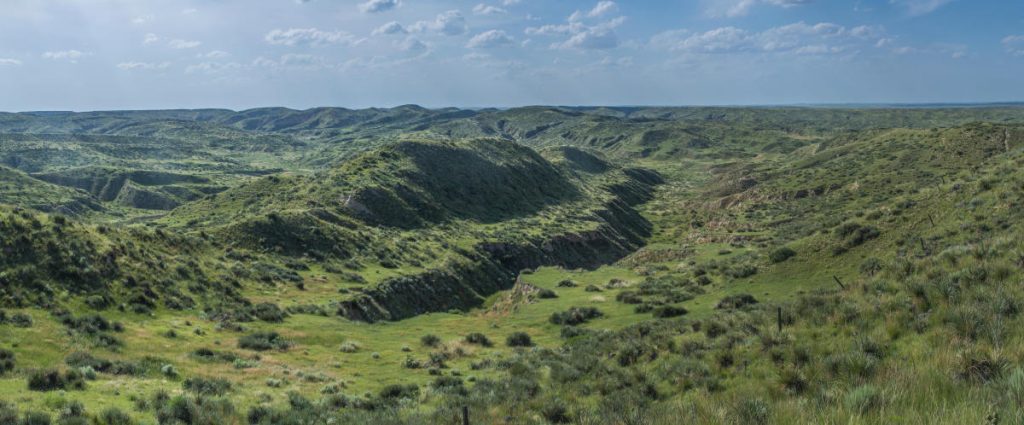
The breaks are located on the extreme northern edge of Cheyenne County. This area of extremely rough terrain, with its deep ravines and gullies is a marked contrast to the plains generally associated with the area. The breaks were formed by wind deposited sand, silt, and clay particles, called loess.The breaks are 36 miles long and approximately two to three miles wide. They extend into Rawlins County and several miles into Colorado. There are several public roads through the breaks, giving visitors some outstanding viewing sites of this rugged wonder. Visitors are asked to please respect the land owners by remaining on the public roads. Location: Head north from the Benton and Washington intersection in St. Francis, cross the Republican River bridge, and turn right at the first fork. Watch for the numbered red-disk signs as you head north into Nebraska on Road 15 (unpaved). In Nebraska, go west on U.S. 34 to Haigler and turn south to K-27. One of the most outstanding views is about 14 miles north of St. Francis. Copies of the Self-Guided Driving Tour can be picked up at the St. Francis Information Kiosk at the Rest Area on US Highway 36 in St. Francis.
Natural Attractions
Arikaree Breaks
Keller Pond

Located on the northwest edge of town, Keller Pond is a great place to have a picnic lunch, go for a walk, or catch some fish.
If you haven’t been to Keller Pond recently, you might not be aware of the many changes that have been made over the past year. Thanks to several grant awards, the recreation site now has a walking trail completely around both east and west ponds, a new walking bridge, young shade trees, and rest stops with benches. The long-term goal is to make Keller Pond a scenic destination for fishing, walking, jogging, and picnics and also to create a walking path between the River Walk and the ponds.
In addition to the improvements made with grant funds, Cheyenne County crews worked to clear out the debris and cattails in the east pond so that it can be more easily accessed for fishing. Brock McAtee Construction was contracted to do the majority of the trail creation work.
Hunting
The St. Francis Wildlife Area is located three miles west and two miles south of St. Francis. The area is bisected by the Republican River, and is a mixture of grasslands, crop fields and riparian timber. The grasslands are occasionally grazed or burned in the spring to increase range health. Food plots are planted, and many consist of wheat, corn, milo, sunflower, and alfalfa.
WILDLIFE
White-tailed deer, Mule deer and Rio Grande turkeys are transient visitors moving on and off the area throughout the year. Spring turkey hunting has been known to produce some exciting action! Pheasant, quail and prairie chickens can be found on the area and offer some good upland hunting for the dedicated hunter. Waterfowl numbers fluctuate from year to year depending on the availability of water. The area can produce a good duck hunt when there is water present in the river bottom. During busier seasons wildlife may be driven off the area from pressure.
FISHING
Two sandpits are located on the St. Francis Wildlife Area, one on each side of the river. These pits are stocked with channel catfish, largemouth bass and bluegill. Quality fishing opportunities are limited due to the pressure these ponds receive. The North Pit is open to walk-in fishing only, while the South pit provides easy vehicle access to the shoreline.